|
|
| |
|
I woke up one
morning thinking about doing an unusual thing here by placing everything
horizontally instead of vertically (not an easy task, I have discovered).
Even though the New Echota museum is not large, it is like walking through
most museums, you tend to experience things more horizontally than
vertically, so here goes . . . . we will give it a try.
Some notes if
you are new to computers: The scroll bar (to move to the right)
should be at the bottom of your screen instead of using the one at the
right (which is for up and down movement). If you are using an
Internet Explorer or Mozilla Firefox browser you can push the F11 key on
your keyboard to get a fuller view, most likely eliminating the up and
down scroll bar. In an old Netscape I use to preview pages, you
click the upper left arrows in the little boxes to maximize the screen.
Your computer will have a way to minimize the command boxes giving you
more viewing area. All of my pages are created for an 800x600
pixel screen resolution. You can select that, if you wish, commonly
through your control panel. If you use a larger configuration, this
particular page will likely run along the top portion of your screen.
|
|
|
|
|
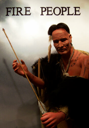
This photo
(left) was taken in 2005 after the mentioned museum display changes were
made. Fire People is one of the names we call ourselves. We
also referred to ourselves as "the principal people" ("aniyunwiya"
phonetically in Cherokee) before being called Cherokee ("tsalagi"
phonetically). Actually, Fire People is a pretty good fit for me, as
friends and family will attest to.
|
|
|
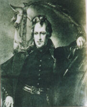
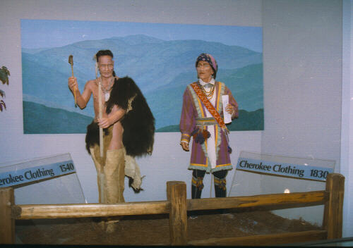
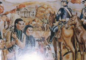
It was
not the first time I had run into the fellow in the opening picture.
He and his counterpart were also in the prior visit displays (photo
below) illustrating the changes in Cherokee clothing between 1540 and
1830. |
|
|
|
 |
|
|
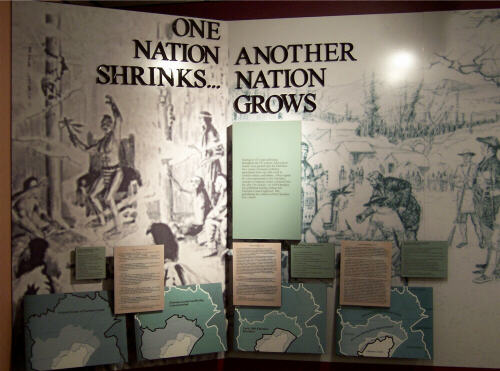
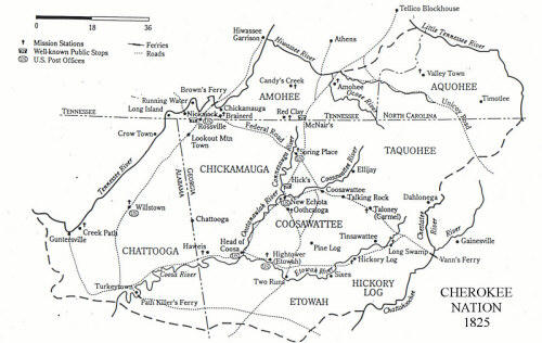
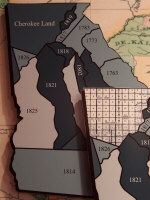
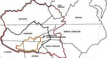
The maps
(below and along the bottom of the next photo titled "One Nation Shrinks")
show the diminishing territory of the Cherokee Nation. We started
out (far left map next over and red line below) with parts of what is
today West Virginia, Virginia, North Carolina, good chunks of South
Carolina, Georgia, Alabama, plus most of Tennessee and Kentucky.
That shrunk significantly after the Revolutionary War (map second from
left next over and black line below), since we had sided with the British
with whom we had trade agreements. By the 1830's we were down to
mostly just what is now northern Georgia (last map next over and yellow
line below). This was after numerous treaties with the new United
States, each of which usually guaranteed we would keep forever what was
left to us after that particular treaty.
|
|
|
|
|
|
|
As you
can see, there is much more information provided than I had time, or
inclination, to photograph. The white map in the middle above is not a
photo from New Echota, but something I picked up online. I
thought the significant detail warranted including it here.
|
|
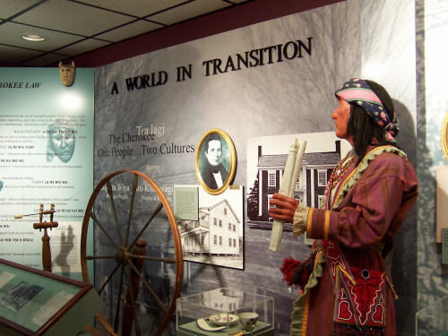
Our
transition history after European contact is pretty impressive.
Evolving from a matrilineal clan system to a constitutionally based
government, we adapted to many of the ways of the whites so well, some
said we had progressed to where we were "more civilized than the white
counties" around us.
|
|
|
|
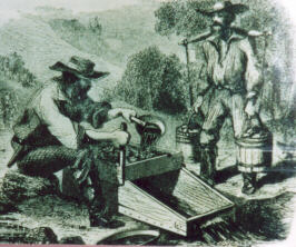
Below left: "The 1828 discovery of gold in the
southeastern part of the Cherokee Nation aggravated the Cherokee-Georgia
controversy. The Georgia legislature passed a law that forbade Cherokees
from mining their own gold. America’s first gold rush (below left)
began in 1829 as thousands of prospectors poured into the Cherokee
Nation."
Georgia governors: George R Gilmer, 1829-1831 &
1837-1839 (below center left) and Wilson Lumpkin, 1831-1835 (below center
right). "Gilmer and Lumpkin led state efforts against the Cherokees.
Georgia wanted to make life so miserable for the Cherokees that they would
leave voluntarily. The Georgia Guard (below right) patrolled
throughout the Georgia part of the Cherokee Nation, enforcing state law
and harassing the Indians. On August 4, 1836, George
Featherstonhaugh recorded this description of the Guard, 'all of them were
unshaven and dirty as they could be . . . many of the men were stout young
fellows, and they rode on, talking, and cursing, and swearing, without any
kind of discipline.'"
|
| |
|
|
| |
|
"It may be
regarded as certain that not a foot of land will ever be taken from the
Indians without their consent." – Thomas Jefferson, 1786.
"Andrew
Jackson (above left), elected president of the United States in 1828, had
earned fame as an 'Indian fighter' in the U.S. Army and supported removal
of the Cherokees. In 1830 he pushed the Indian Removal Act through
Congress which called for eviction of all Southeastern Indian Tribes."
"The Cherokee Nation covered over 4 million acres in
Georgia. Georgia’s claim to Cherokee lands dated back to 1802. At
that time Georgia ceded its western lands to the U.S. Government partially
in exchange for a promise that all Indians in the state would be removed
as soon as it could be peacefully done."
|
|
|
|
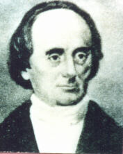
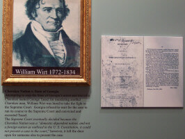
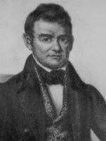
"Cherokee
Nation v. State of Georgia – Attempting to stop the State of Georgia’s
arrest and trial of a Cherokee named George Tassel for murdering another
Cherokee man, William Wirt (photo at left) was hired to take the fight to
the Supreme Court. Georgia refused to wait for the case to run its course
to the Supreme Court and convicted and executed Tassel. The Supreme
Court eventually decided because the Cherokee Nation was a ‘domestic
dependent nation, and not a foreign nation as outlined in the U.S.
Constitution, it could not present a case to the court,‘ however, it
left the door open for someone else to present the case."
"In 1832, the
case of Worcester vs Georgia went to the U.S. Supreme Court in Washington
D.C. The court ruled in favor of Worcester and Cherokees saying Georgia
law did not extend over the Cherokee Nation." [Worcester was a
missionary working with the Cherokees, who was arrested by the state of
Georgia for violating their Indian laws. You will see more about him
later.]
|
| |
 |
|
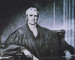
"The
Cherokee Nation is a distinct community, occupying its own territory
. . . in which the laws of Georgia can have no force, and which the
citizens of Georgia have no right to enter but with assent of the
Cherokees themselves . . . The acts of Georgia are repugnant to the
Constitution, laws, and treaties of the U.S." From
Worcester vs Georgia, written by Chief Justice John Marshall, 1832
(photo at left).
|
|
|
 |
|
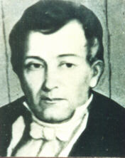
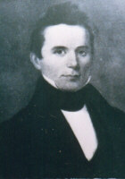
"Our
adversaries are generally down in the mouth . . . there is rejoicing
in the [Cherokee] Nation on the decision of the Supreme Court upon the
Cherokee case." – Principal Chief John Ross (photo left), March
30, 1832
"The
arrival of this decision has been like a shower of rain on the thirsty
vegetables of the earth. All are easy, content, and merry.
Innumerable celebration of this decision by feasts and dances, are
taking place. Every Indian now knows he stands upon a solid
foundation." - Elijah Hicks, March 24, 1832
|
| |
|
|
 |
|
"It is
glorious news. The laws of the state are declared by the highest
judicial tribunal in the country to be null and void. It is a
great triumph on the part of the Cherokees . . . The question is
forever settled as to who is right and who is wrong." - Elias
Boudinot (photo left), March 7, 1832
"In
violation of the Supreme Court, Georgia continued its annexation of
Cherokee lands. The Cherokee Nation was divided into ten
counties, surveyed and given away to white Georgia citizens in a land
lottery."
|
|
|
|
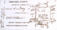
"Survey
plat of Lot#121-4-2 showing home of Judge James Daniel on the Federal
Road. 'Our country is now overrun with surveyors, laying off the
land into small sections.' CHEROKEE PHOENIX, April 21, 1832"
|
|
|
| |
|
|
|
|
|
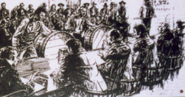
"October
1832 – Georgia officials watch as the names of winners of Cherokee
land are drawn in the lottery."
|
| |
|
"The
State of Georgia is about to perpetrate one of the most shameless
and atrocious depredations that was ever committed in times of
profound peace, upon any nation or people." CHEROKEE PHOENIX,
October 27, 1832 "Our papers from Georgia brings us accounts
of the operations of the lottery at Milledgeville, and the drawing
of the lands, and gold mines of the Cherokee Nation . . . the
magnitude of this atrocity on our property has created feelings of
astonishment." CHEROKEE PHOENIX, November 11, 1832
|
|
|
|
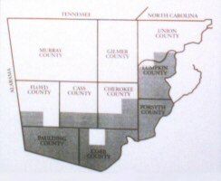
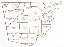
"The map
below (left) shows the Georgia part of the Cherokee Nation and the 10
counties created in 1832. The tinted area was divided into 40 acre 'gold
lots' and the rest divided into 160 acre 'land lots.' The other map below
(right) shows the present 24 Georgia counties that now occupy the same
region, along with the year they were established."
"The
legislature of Georgia passed an act dividing the Cherokee country in 10
counties . . . but we ask, what have become of our 16 solemn treaties
which guaranteed forever to the Cherokees the integrity of their
territory? They have been destroyed and put under foot by the same rule
that one man would murder another and rob him." CHEROKEE
PHOENIX, May 4, 1833
|
| |
|
|
| |
|
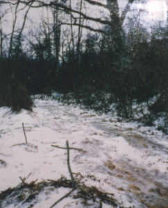
"The
state legislature passed a law that prohibited the Cherokee Nation
from meeting in Georgia [claimed boundaries] except for the purpose
of ceding land. The last council meeting was held at New Echota in
October 1830. From 1832-1837 the Cherokee council met at Red
Clay, Tennessee." |
| |
|
[Today
the Council grounds at Red Clay is a state historical area] |
|
|
|
|
|
"The
Georgians have shown a grasping spirit lately . . . they are willing
to buy these lands . . . I know the Indians have an older title than
theirs . . . we obtained the land from the living God above.
They got their title from the British. Yet they are strong and we
are weak. We are few, they are many. We cannot remain
here in safety and comfort." - Major Ridge, December
1835
|
| |
|
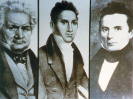
"A
group of influential Cherokees led by Major Ridge (above left), John
Ridge (above middle), and Elias Boudinot (above right) began to
question the wisdom of a continued fight against the political
forces of white America. They concluded that emigration west
was the only possible alternative. Supporters of removal met at New
Echota in December 1835. The Treaty of New Echota ceded to the
U.S. all tribal lands east of the Mississippi river in exchange for
$5,000,000 and a tract of land in what is today northeastern
Oklahoma. The treaty was never approved by the Cherokee
government."
|
| |
Have you been
noticing the the looks and dress of these early 1800's Indians? It
should by now be bursting any stereotype image you might have had of the
"savages" our Manifest Destiny moved.
|
|
|
|
"I am
still in the midst of efforts to prevail on the United States
government to turn aside . . . the ruin they are bringing on my
native country . . . and for what? Have we done any wrong? We have a
country which others covet. This is the only offense we have ever
been charged with."
-
Principal Chief John Ross, May 14, 1838
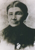
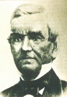
I am
assuming this to be a much later picture of Principal Chief John
Ross, but I did not photograph any notes about the date of the
image.
|
|
|
| |
|
"Cherokee officials, led by Chief Ross, appealed to the U.S.
Government that the Treaty of New Echota was fraudulent. Petitions
signed by more than 15,000 Cherokees who opposed it were presented.
After heated debate, on May 17, 1836 the U.S. Senate approved the
treaty by a margin of one vote. President Jackson signed it into law
on May 23,1836 giving the Cherokees two years to move west
voluntarily."
|
| |
Gilmer County
is one of the original Georgia counties formed within the Cherokee Nation
at this time. It was not displayed at New Echota, but Leslie Thomas
has shared with me a four-part series of articles she wrote regarding the
county's Cherokee History. For a little more historical detail,
READ THE
TEXT OF THE LESLIE THOMAS ARTICLES.
|
|
|
 |
|
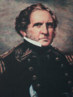
In May 1838, General Winfield Scott and 7,000 U.S. Troops were sent
into the Cherokee Nation.
I took this photo of General Scott's
portrait at New Echota, but the
text below is from a Google
search of his name. |
| |
|
Winfield Scott (June 13, 1786 – May 29, 1866) was a United States
Army general, diplomat, and presidential candidate. Known as
"Old Fuss and Feathers" and the "Grand Old Man of the Army", he
served on active duty as a general longer than any other man in
American history and most historians rate him the ablest American
commander of his time. In 1838, following the orders of
President Andrew Jackson, he assumed command of the "Army of the
Cherokee Nation", headquartered at Fort Cass and Fort Butler, and
carried out the initial removal of Cherokee Indians from Georgia,
North Carolina, Tennessee, and Alabama - what later became known as
the Trail of Tears.
|
|
|
|
|
|
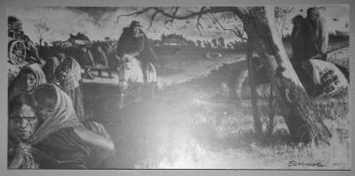
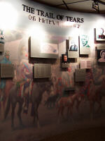
"On
Saturday, May 26, 1838, the forced removal of the Cherokees began.
During the next three weeks, 15,000 men, women, and children were
forced from their homes at gunpoint and imprisoned in the forts.
Later, the Indians were transferred to 11 internment camps, 10 of
which were located in Tennessee."
|
|
|
| |
|
"Chief
Ross returned from Washington D.C. in early July, 1838. Saddened by
the condition of his imprisoned people he asked federal officials to
permit the Cherokees to oversee their own removal. They agreed and
Ross organized the Cherokees into 13 detachments ranging in size
from 700 to 1,600 persons. Ross selected leaders to supervise each
of the 13 detachments. A terrible drought delayed the start of the
journey until October, 1838. Nine detachments left during October
and four during November. Most groups traveled the northern route
starting at Calhoun, Tennessee; through Tennessee, Kentucky,
Illinois, Missouri, and Arkansas. A harsh and early winter followed
the summer drought. Improper food and clothing along with road
conditions, illness and the distress of winter made death a daily
occurrence. The exact number of fatalities is not known; however,
estimates range from a total of several hundred to 4,000 deaths in
the concentration camps and on the 800 mile journey west. The
Cherokees who survived, arrived in Indian Territory (now
northeastern Oklahoma) during January, February, and March 1839
after spending an average of 116 days on the trail."
|
|
|
|
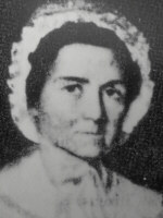
"Quatie Ross
(below left), wife of Chief John Ross. During the Trail of Tears,
with her health already poor, she gave her blanket to a sick child.
The child recovered but Quatie developed pneumonia and died."
"Eliza
Missouri Bushyhead (below right), the daughter of Rev. And Mrs. Jesse
Bushyhead, was born January 3, 1839 just after her parents’ detachment
crossed the Mississippi River into Missouri. Eliza was one of about
75 babies born on the Trail of Tears."
|
| |
| |
|
"During
the night a Cherokee woman died in the camps. Though she had
given birth to a child but a few days before, yet last evening she
was up and no danger apprehended, but in the morning she was found
dead, with the infant in her arms." - Rev. Daniel S. Buttrick,
December 13, 1838 |
|
|
|
"Murder
is murder and somebody must answer . . . somebody must explain the
4,000 silent graves that mark the trail of the Cherokees to their
exile. I wish I could forget it all, but the picture of 645
wagons lumbering over the frozen ground with their cargo of
suffering humanity still lingers in my memory." - John G.
Burnett, December 11, 1890 – He was a private in the U.S. Army
during the Cherokee Removal.
|
|
|
| |
|
"It
affords me great pleasure to be able to apprise you of the entire
removal of the Cherokee Nation of Indians to their new homes west of
the Mississippi. The measures authorized by Congress . . .
have had the happiest effect, and they have emigrated without any
apparent resistance." Speech to Congress by
President Martin Van Buren, December 3, 1838.
|
|
|
|
|
| |
|
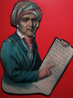
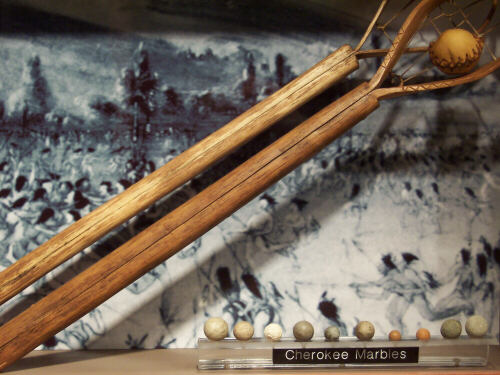
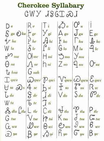
There were
other items of a more positive note in the museum, including the
development of the Cherokee Syllabary (left) by Sequoyah (above left), and
some fun and games stuff (more on Cherokee ballgames later) like Cherokee
Marbles.
click here to
read the CNC Brochure Text about the syllabary
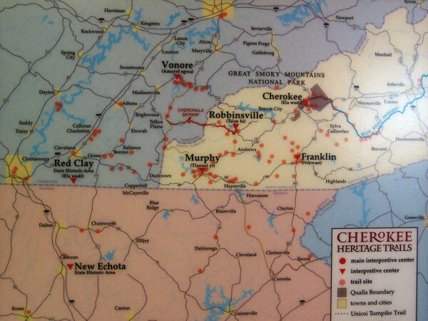
The last item
I will display here is a map (right) I took a picture of at New Echota.
It was so I could remember the locations of various Cherokee Heritage
sites and trails I might want to visit someday. Then we'll
head out to tour the grounds.
|
|
|
 |
|
|
|
|